What to check on a GPS / DGPS.
GPS is a satellite constellation-based system: the receiver measures signal travel time from four or more satellites to compute a position, typically accurate to 3-10 metres depending on satellite geometry and atmospheric conditions. DGPS improves on this by comparing the satellite signal against a reference station at a known fixed location - historically shore-based radio beacons, increasingly delivered as a correction stream over satellite or terrestrial data links - and broadcasting the error so the shipboard receiver can subtract it out. Unlike the gyrocompass or log, which derive heading and…
What sets GPS/DGPS apart from other position sources
GPS is a satellite constellation-based system: the receiver measures signal travel time from four or more satellites to compute a position, typically accurate to 3-10 metres depending on satellite geometry and atmospheric conditions. DGPS improves on this by comparing the satellite signal against a reference station at a known fixed location - historically shore-based radio beacons, increasingly delivered as a correction stream over satellite or terrestrial data links - and broadcasting the error so the shipboard receiver can subtract it out. Unlike the gyrocompass or log, which derive heading and speed from onboard sensors, GPS/DGPS is entirely dependent on an external signal, which is both its strength (no drift, no calibration against a known reference needed) and its weakness (jamming and spoofing are real operational threats in some sea areas).
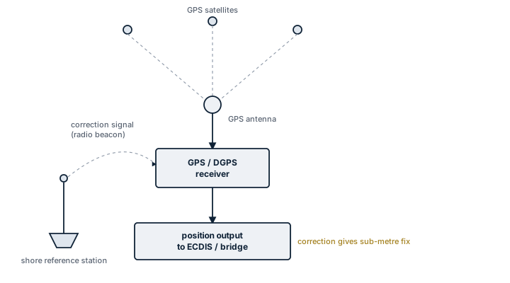
Main components
- Antenna - mounted with a clear sky view, free of obstruction from masts, funnels or radar scanners that can cause multipath errors or signal blockage.
- Receiver / processor unit - tracks multiple satellites simultaneously, computes the position solution and applies differential corrections where available.
- Differential correction input - a beacon receiver, satellite-based augmentation feed, or network correction service depending on system fit.
- Display / interface unit - shows position, course over ground, speed over ground, and feeds the data onward over a serial or network bus to ECDIS, autopilot, AIS and VDR.
- Backup power and independent supply - required so the primary position source survives a mains failure.
Selection / Sizing
The deciding factors are not capacity but accuracy class, update rate, and interface compatibility. SOLAS-fitted vessels need a receiver that meets the IMO performance standard for shipborne GNSS equipment and outputs standard NMEA sentences that downstream systems such as ECDIS and AIS can consume without translation. Multi-constellation receivers that track GPS alongside GLONASS, Galileo or BeiDou give more visible satellites and better resilience if one constellation degrades, which is increasingly the standard fit rather than an extra. Update rate (commonly 1 Hz) and horizontal accuracy specification should match what the ECDIS and dynamic positioning systems, if fitted, actually require.
Regulations / Class
SOLAS Ch. V requires ships to carry a receiver for a global navigation satellite system, or a terrestrial radio navigation system, suitable for the voyages undertaken. IMO performance standards (resolution MSC.112(73) and related) set the accuracy, integrity and update requirements for shipborne GPS. Most flag states also require an independent second position-fixing source or method as backup, since GPS alone is a single point of failure if jammed. Survey is typically a functional check of position accuracy and interface output during periodic and annual surveys rather than a dedicated GPS-specific class requirement.
Typical faults
| Fault | Consequence |
|---|---|
| Antenna cable corrosion or connector failure | Intermittent or total loss of satellite signal, position freezes or drops out |
| Loss of differential correction signal | Position reverts to standard GPS accuracy without warning if not alarmed properly |
| GPS jamming or spoofing in contested sea areas | False or degraded position fed silently to ECDIS and autopilot |
| Antenna shadowing by superstructure on certain headings | Periodic signal dropout, position jumps when satellites reacquire |
| Firmware not updated for GPS week rollover or leap second handling | Sudden large position or time error after a rollover event |
What to look for in a supplier
- Type approval certificate confirming compliance with the relevant IMO performance standard for the flag and trade.
- Multi-constellation tracking capability rather than GPS-only, for resilience.
- Clear documentation of NMEA output sentences and baud rates for integration with existing ECDIS and AIS.
- Manufacturer support for firmware updates addressing known rollover and interference issues.
Never treat a steady GPS position on the display as proof it is correct - cross-check against radar range and bearing to a known object whenever jamming is a possibility in the area, and log any unexplained position jump immediately.