What to check on a GPS/GNSS.
GPS/GNSS receivers are the position half of the bridge's position-and-heading pair, distinct from the gyrocompass, which only reports direction. A GNSS set computes latitude, longitude, speed over ground and course over ground from satellite ranging signals, feeding that position into ECDIS, AIS, VDR and the autopilot. The term GNSS rather than GPS matters commercially: most SOLAS-class receivers now track GPS, GLONASS, and increasingly Galileo or BeiDou simultaneously, because relying on one constellation leaves a single point of failure if that system is degraded or jammed.
What makes this type
GPS/GNSS receivers are the position half of the bridge's position-and-heading pair, distinct from the gyrocompass, which only reports direction. A GNSS set computes latitude, longitude, speed over ground and course over ground from satellite ranging signals, feeding that position into ECDIS, AIS, VDR and the autopilot. The term GNSS rather than GPS matters commercially: most SOLAS-class receivers now track GPS, GLONASS, and increasingly Galileo or BeiDou simultaneously, because relying on one constellation leaves a single point of failure if that system is degraded or jammed.
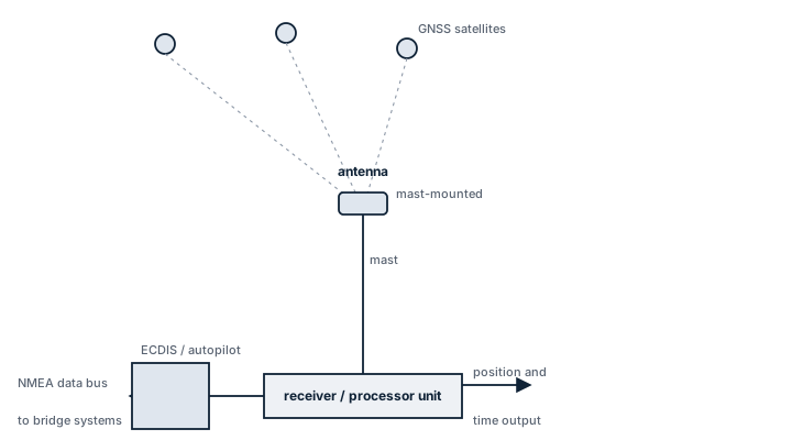
Main components
Antenna
A dedicated deck-mounted antenna with clear sky view, positioned away from radar scanners and funnel exhaust that can cause multipath or signal blockage. Antenna cable length and loss directly affect the receiver's minimum signal-to-noise margin.
Receiver unit
Processes the ranging signals from multiple satellites and constellations, resolves position by trilateration, and outputs NMEA 0183 or NMEA 2000 sentences (GGA, RMC, VTG) to the ship's network. SOLAS-approved units include self-test and integrity monitoring (RAIM) that flags degraded satellite geometry.
Differential correction input
Many installations accept DGPS beacon or satellite-based augmentation corrections to tighten accuracy from the tens-of-metres standalone figure down to a few metres, relevant in pilotage waters and dynamic positioning work.
Selection and sizing
- Number of constellations and frequencies tracked; dual-frequency (L1/L5 or equivalent) receivers resist ionospheric error far better than single-frequency
- Update rate, usually 1 Hz for standard navigation but higher for dynamic positioning interfaces
- Output interface compatibility with existing ECDIS, AIS and VDR wiring (NMEA 0183 talker ID conventions still trip up retrofits)
- Jamming and spoofing resilience, an increasingly practical selection criterion in regions with reported GNSS interference
Regulations and class
SOLAS Chapter V requires ships to carry a receiver for a global navigation satellite system or a terrestrial radio navigation system, suitable for the entire voyage. IMO performance standards (resolution A.819 and successors covering GPS, GLONASS and multi-constellation combined receivers) set the accuracy, integrity and self-monitoring requirements a type-approved unit must meet. Class societies require the installation to be included in the periodic navigation equipment survey and the unit's type approval certificate kept on board.
Typical faults
- Antenna cable degradation from UV and salt exposure, causing intermittent signal loss that reads as position jumps rather than a clean failure
- Loss of one constellation during a solar event or deliberate interference, which a single-constellation-only receiver cannot compensate for
- Firmware not updated for GPS week-number rollover or leap-second handling, producing incorrect time stamps that propagate into AIS and VDR logs
- Multipath error near steel superstructure giving a stable but wrong position, which is more dangerous than an obvious failure because it does not trigger an alarm
What to look for in a supplier
- Current IMO type approval certificate matching the flag state's accepted list
- Multi-constellation, ideally multi-frequency capability rather than legacy single-frequency GPS-only sets
- Documented RAIM and integrity alarm behaviour, not just an accuracy specification
- Interface compatibility confirmed against the ship's actual ECDIS and AIS model, not a generic NMEA claim
Cross-check GNSS position against radar range and bearing to a known landmark on entering pilotage waters; a receiver that has quietly locked onto a spoofed signal still reports a clean fix with no alarm.