GPS Receiver
A marine GPS receiver reports position only; it says nothing about heading unless paired with a second antenna for GNSS compass mode, which is why SOLAS still requires an independent, non-GNSS means of fixing position.
Read more — GPS Receiver explained ▾
What sets this receiver apart from other position sources
A marine GPS receiver decodes signals from the US GPS constellation and, on most modern sets, also from GLONASS, Galileo and BeiDou, giving a fused multi-constellation fix rather than relying on GPS alone. It answers one question only: where is the antenna right now. It does not tell the bridge which way the bow points -- that is the gyrocompass's job -- and it does not replace a second, independent means of fixing position, which SOLAS still requires precisely because a single GNSS source can fail or be spoofed without warning.
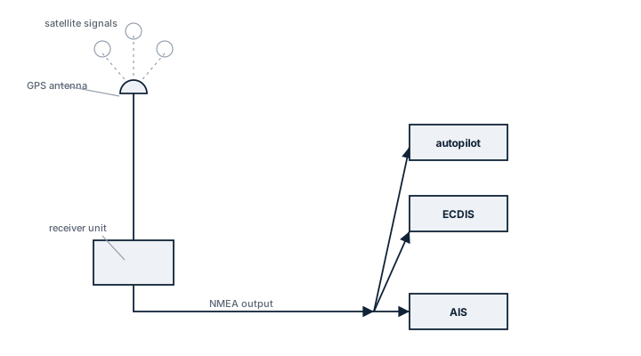
Main components
Antenna
A dome-mounted active antenna with integral low-noise amplifier, positioned with a clear sky view away from radar scanners and funnel exhaust, which otherwise degrade signal-to-noise ratio.
Receiver / processing unit
Tracks 12 to 30+ satellite channels simultaneously, computes a weighted position solution, and applies differential corrections where available (SBAS such as EGNOS or WAAS, or a local DGPS beacon feed).
Output interfaces
NMEA 0183 or NMEA 2000 serial output feeding ECDIS, AIS, VDR and autopilot in parallel; many bridges wire two receivers into a changeover or voting arrangement so a single antenna fault does not blind every downstream system at once.
Selection criteria
- Number of tracked constellations and channels -- more channels shorten re-acquisition time after a mast shadow or heavy roll.
- Update rate, typically 1 Hz for standard navigation, higher for dynamic positioning feeds.
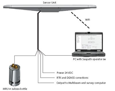
- Differential correction support (SBAS, RTK) where the trade requires metre-level or sub-metre accuracy, for example dredging or offshore support work.
- Output protocol compatibility with the existing ECDIS and VDR interface list.
Regulations and class
SOLAS Chapter V requires vessels to carry a receiver for a global navigation satellite system, or terrestrial radio navigation system, appropriate to the voyage, and to maintain a means of determining position that does not depend solely on one GNSS. Class societies survey the installation as part of the navigation equipment audit rather than as a standalone item, checking that the antenna position and cabling match the approved drawing and that backup arrangements are functional.
Typical faults
- Antenna cable corrosion at the deck gland, causing intermittent signal loss that looks like a satellite outage rather than a wiring fault.
- Loss of differential correction when the vessel moves out of SBAS or beacon coverage, degrading accuracy without triggering an alarm on older receivers.
- Multipath error near steel superstructure or containers, producing a stable but wrong fix that the receiver reports with high confidence.
- Firmware not updated for GPS week-number rollover, which can jump the reported date and confuse logging systems.
What to look for in a supplier
- Type approval certificate matching the flag state and class society of the vessel, not just a generic marine label.
- Documented output protocol list so integration with the existing ECDIS and AIS does not need a separate converter.
- Availability of spares and firmware updates well beyond the initial warranty period, given typical fit life of ten years or more.
Two receivers from the same manufacturer and the same antenna run are still a single point of failure if they share a mast position and a power supply -- route the second antenna and cable separately if the redundancy is meant to mean anything during a storm or a mast strike.
10 manufacturers · 84 models
Furuno
19
Kongsberg Maritime
13



JRC (Japan Radio Co)
11
Hemisphere GNSS
10
Simrad
10
Garmin Marine
7
Trimble Marine
6
Leica Geosystems
3
Wärtsilä
3
Who can you trust with this job?
The global maritime company directory — brand coverage, certificates and direct contact routes to maritime suppliers.
Open network →Sourcing this part?
One request. You get suppliers who actually carry it, not a search page.
Request partsCan’t read the plate?
Photograph it. We identify make and model and take you to the datasheet.
Try itRed Sea and Bab el-Mandeb
Rerouted transits, war-risk cover, and what it means for schedules and repairs.
17 reports